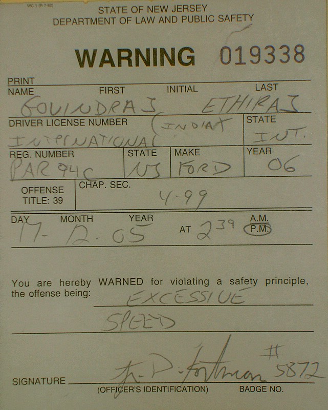
Exhibit A: State of New Jersey vs GE
Looking back, I think I saw the state trooper’s car in what you could call the general eye-horizon. I saw it parked on a bridge as I sped beneath on the 16-lane New Jersey Turnpike. I was heading towards Washington DC and was hoping to make it to Baltimore by sunset. Then I saw it, moving off the bridge, speeding down the ramp and joining my side of the Turnpike.
The rest is not a blur. In seconds, the blue-red lights strobes were right behind me, the cop car tailgating dangerously but purposefully. I had cut back on the speed instinctively. But it was too late. In the rear view mirror, I could see the policeman shaking his face like he was saying, “Don’t buddy, don’t make it worse for yourself.” I looked again in the rear view to ensure I was the chap he was after and began slowing down.
Our cars pulled over. I rolled down the windows and allowed the freezing air into the car. He didn’t get off his car right away. First pulled out a microphone and spoke for an indeterminable length of time. Presumably, he called in the details; Ford 500, maroon colour, lone Asian driver. Hopefully he did not say maybe armed and dangerous or maybe he did. Then he got out of the car, turned back, went right around his car and then came over to my window on the right side. Interesting, had not noticed this specific move in the movies.
Emboldened I Am
“Good afternoon sir, your driving license and registeration please.” Handed over the stuff. “Okay, you were doing close to 90 miles in a 65 miles per hour zone. Are you in a hurry to get somewhere ?” “Not at all,” I said matter of factly. “Your hand was near your ear. Were you talking on the phone ?”. “No,” I said. On my side, huge trailers roared past, buffeting the car with their slipstream. The temperature on the dashboard console read roughly near 0 C.
To cut a long story short, he returned with the license to his car, spent an agonizing 5 minutes conferring with someone on the radio, wrote out something on a piece of paper and then returned with a ticket. By now, my name and photograph must have flashed through the entire INS database and my visa status checked. Maybe I was now noted down as a potential law-breaker. But nothing that one could do, now. We said our goodbyes and I was off, watching the speedometer very closely.
This was the first time I was driving alone in the US. I’ve always had company in the past. Its because I was driving alone and did not have a law-abiding local resident with me that I perhaps overshot the limit. And I was driving alone because I was emboldened by a software, not the car. You know it too, its Google Maps or MapQuest or Yahoo Maps. Powerful mapping software that empowers you totally. And that’s why I think I was so cheerfully tearing down the Turnpike that afternoon.
Nobody gives you directions in the United States anymore. “Will we meet for lunch ?” is all my friend in Washington DC asked. And he gave me his address, including the critical zip code. Any other time, not giving directions would be considered rude. I think its reached a point where giving directions will be rude because it will be a waste of time and an insult to the other party’s ability to navigate MapQuest/Google Maps. All you do is to punch in the zip code and it opens up in seconds.
Google Maps It Out
Nobody will necessarily accompany you if you can drive, because they need not show you the way. Merely hand over a print out. Invitations to social events are accompanied by a webpage with directions, printed from Google Maps or MapQuest. Its amazing how everyone trusts it so blindly. I suspect it also takes away an important conversation starter..”So, where do you stay ?” “Oh, I stay off Route 1, Exit so and so..” Now, I can see the smug one saying, “Zip Code so and so,” or handing over a printout.
I’ve used Mapquest before, back in India, for checking locations in the US. A few years ago I used MapQuest when driving through. It worked well. In some ways, its a little more friendly than Google Maps. But Google Maps has changed the equation because it combines with Local Search, satellite images and Google Earth. The combination of this makes finding directions more exciting and more simple. And you feel you don’t need to ask anyone for any thing.
Moreover, thanks to Google, whose search function you use in any case, drifting into Maps comes easily. Want to go to the corner store five minutes from the house but don’t know whether to take the first left or right when you leave the apartment complex. Well, try Google Maps. It paints the directions on the local map. Of course you can use satellite images or Google Earth to figure out how the store looks from space. And with Google Local you can even get the address, phone numbers and so on.
As Good As The Original
Want to visit the nearest malls, museums or movie halls near by. Find out their names on Yahoo Maps (for example), their addresses and directions to them from wherever you are. Find out about ATMs and gas stations as well. Yahoo has a dynamic map with the map pointer moving as you scroll down, lets say, ATM locations. There is a lot more which you can browse around.
I discovered that all private apartment complexes are registered with the mapping guys. So, even if there is a new apartment complex or condominium that’s come up, anywhere in the U.S.A, chances are it will be updated at the county level and picked up by the mapping guys instantly. So, maps take you right to the doorstep. Why then, would you want to ask for directions ? Unless there is a road blockage which the mapping software won’t tell you. There will be other sites that could do that, at least in some cities.
The software and the algorithms that power the search are only as good as the primary information they have. And that’s what is truly amazing. Doing it once is bad enough. And then updating it constantly and having the systems in place to do is not simple. And it happens. All the direction searches I have done on MapQuest, Yahoo and Google have turned out to be remarkably accurate for the smallest of gullies. Though they could take different approaches.
Can India Do This One ?
There is a lot of GIS effort on in India (which presumably would lead to similar databases) but our basic mapping is in such a mess that you wouldn’t know where to start. Or, its locked up in some Surveyor General’s office that you and I cannot access it. There are a few brave efforts like Escorts' city guides, I don’t know about the rest and would be happy to. If you want to learn about opening up seemingly private domain information to the public domain, learn from the United States.
Just imagine the huge savings in time and effort at every turn. I choose which ATM to go by looking at the distance on Yahoo Maps, or the nearest coffee shop. Or whether I should walk to the local library or wait for someone to pick me up. And which cab company I can call by seeing who is closest. Its amazing how completely in control over your destiny you are. But you should check speed limits as you drive. America takes speeding violations very seriously. Don’t think any of the map portals mention them specifically.
http://www.guardian.co.uk/science/story/0,3605,1674095,00.html?gusrc=rss
Guardian says, "With Galileo, services that can position goods, people and vehicles to within three feet will be possible. While ramblers might make do with the free signal, emergency services could use an encrypted, more accurate signal to guide ambulances, fire engines or police cars to their locations with unprecedented precision.
Mike Dillon of ESYS, an electronics company involved in the project, says that ultimately Galileo could be used for automatic road charging, and improving safety on Europe's roads by warning drivers of accident blackspots, junctions or curves in the roads. "Right now there are around 1.3bn accidents causing 40,000 fatalities each year," he said. "That's the equivalent of two jumbo jets full of passengers crashing every day."